 Brasil
 Paraguay
 Argentina


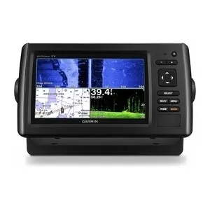
Sonar Garmin Echo Map 74SV
Disponível desde 04 de Agosto de 2018
Última listagem em 10 de Fevereiro de 2026
Compartilhar

código: #5021
Por:
US$ 650,00
R$ 3.432,00
* Os preços e a disponibilidade estão
sujeitos a alterações sem aviso prévio.
Informar preço incorreto ou indisponibilidade
Especificações de Sonar Garmin Echo Map 74SV
| INFORMAÇÕES BÁSICAS | |
|---|---|
| Marca | Garmin |
Informações Extras
7-inch Combo with ClearVü and SideVü Scanning Sonar
High-contrast color display with keypad control with preloaded U.S. BlueChart® g2 maps
Built-in ClearVü and SideVü scanning sonar with the clearest images on the water¹
Built-in 500 W (RMS) HD-ID™ sonar (4,000 W peak-to-peak)
5 Hz Internal GPS updates position and heading 5 times per second
Tilting, quick-disconnect mount
echoMAP 74sv includes a 7-inch high-contrast color display with automatic backlight adjustment. Fast, responsive 5 Hz GPS/GLONASS refreshes your position and heading 5 times each second to make your movement on the screen more fluid. echoMAP comes with 1 transducer for 50/200 kHz HD-ID sonar and Garmin DownVü™/Garmin SideVü™, the clearest scanning sonars on the water. It also supports Minn Kota® and MotorGuide® trolling motors with integrated transducers. The combo's cords plug directly into the mount, allowing you to quickly install and remove your device from power and the mount. Transom mount included with version of device that includes a transducer.
Clearest Scanning Sonar on the Water
Garmin DownVü scanning sonar gives you a nearly photographic image of what passes below your boat. Garmin SideVü scanning sonar gives you a crisp, clear view of what lies up to 750-feet off to each side of your boat. You clearly see structure, submerged objects and fish. Traditional Garmin HD-ID sonar and both DownVü and SideVü scanning sonar are combined into one transducer. Also provides HD-ID support for Minn Kota and MotorGuide trolling motors with integrated transducers. The echoMAP 74sv also includes sonar-recording capability that coordinates the timing of the sonar return with your boat's position and saves digital information for playback on a computer using free HomePort™ planning software. Use the User Data Sharing Cable to share waypoints and routes between multiple devices.
Preloaded BlueChart g2 maps
Covers the coastal U.S. and Bahamas – East Coast, West Coast, Gulf of Mexico, U.S. side of the Great Lakes. Includes all U.S. charts for the entire coastline and the Bahamas. Includes everything available on NOAA charts. In addition to the basic charts, tidal stations, currents, depth contours, IALA symbols and included fishing charts, BlueChart g2 offers smooth transitioning between zoom levels and more seamless continuity across chart boundaries. You can customize your screens with Safety Shading which allows you to contour shade for all depth contours shallower than what you determine is your safe depth. Fishing charts emphasize bathymetric contours with less visual clutter on the display. And there’s also a choice of standard 2-D direct overhead or 3-D “over-the-bow” map views for easier chart reading and orientation.
Heading and Position Refreshed 5 Times per Second
Fast, responsive 5 Hz GPS/GLONASS refreshes your position and heading 5 times each second to make your movement on the screen more fluid. It makes dropping up to 5,000 accurate waypoints and finding your way back to your secret fishing hot spots quick and easy.
Take Your echoMAP with You
When you’re off the water, it’s easy to keep your echoMAP safe and secure. You don’t have to mess with plugging and unplugging wires from the unit because the cords plug directly into the mount. This allows you to quickly install and remove your echoMAP from power and the mount.
Upgrade with the Best Garmin Maps on the Water
A single microSD™ card slot provides expandable memory for accessory map purchases such as LakeVü HD, LakeVü HD Ultra or BlueChart g2 Vision. LakeVü HD Ultra and BlueChart g2 Vision provide exclusive Garmin Auto Guidance that directs you right to your hot spots by instantly creating an on-screen path based on your boat’s specifications that you can follow to avoid shallow water and other charted obstructions.
Enhanced Auto Guidance
Just enter the location where you want to go and patented Garmin Auto Guidance³ technology instantly searches through relevant charts to create a virtual pathway on the display that helps you avoid low bridges, shallow water and other charted obstructions en route.
Better still, with enhanced Version 2.0, you now have access to even more features and capabilities. You’re able to adjust the calculated Auto Guidance pathway by inserting “via” points at interim stops or landmarks along your desired route. You can easily review hazard points along your calculated path. And you can even engage your compatible Garmin autopilot to follow the Auto Guidance route, automatically. Other 2.0 enhancements give you the ability to calculate arrival times at any point on your route (great for timing arrivals to correspond with bridge openings and other time-critical events). Better still, you can now save your plotted Auto Guidance paths for future navigation by backing them up on an SD™ card with your BlueChart® g2 Vision® or Garmin LakeVü™ HD Ultra cartography².
GPX Waypoints Transfer
If you have waypoints, tracks or frequently used routes stored on another manufacturer’s GPS product – or on a Garmin handheld device – now it’s easier than ever to transfer those items to your new Garmin chartplotter, via industry-standard GPX software formatting. GPX is an open standard format for GPS data exchange across platforms and applications. With this easy-to-use interface technology, Garmin has taken “no waypoint left behind” to a whole new level of trade-up convenience.
Create your own HD maps
Quickdraw Contours is a free, easy-to-use software feature that is already installed on your compatible Garmin device. It instantly creates your very own personalized HD fishing maps with 1-foot contours. Tailor them to fit your needs. They are your maps. You own them. Keep the data to yourself or share it with Garmin or your friends. There’s no special surveying expertise required. You just fish while it creates maps. You don’t have to wait around or send your files away like other mapping software requires — your results appear instantly. Use with any Garmin Panoptix™, any HD-ID™, any CHIRP-enabled, Garmin DownVü transducer or NMEA 2000®-compatible depth transducer. Have more than 1 sonar device installed onboard? Quickdraw Contours automatically selects the most capable sonar device to provide the very best results for you!
Multiple Depth Range Shading
Designate up to 10 different depth ranges each with its own color. Makes it easier to view target depths at a glance.
¹Applies to versions with transducer included only. No transducer versions support 50/200 kHz, 77/200 kHz and Garmin DownVü/SideVü transducers, sold separately. See transducer selection guide for complete list of compatible transducers.
²BlueChart® g2 Vision® or Garmin LakeVü™ HD Ultra SD card is required for this technology.
³Auto Guidance is for planning purposes only and does not replace safe navigation operations


")


