


DETALHES DO PRODUTO
| INFORMAÇÕES BÁSICAS | |
|---|---|
| Marca | Garmin |
INFORMAÇÕES DO PRODUTO
Fish with the Power of CHIRP
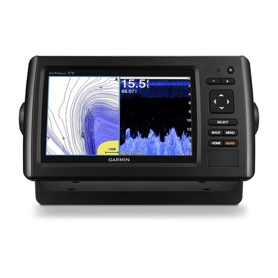
7-inch color display with keypad control
Includes transducer with high wide CHIRP and CHIRP ClearVü
Preloaded LakeVü HD maps cover 17,000 total lakes, of which 13,000 are HD lakes with 1-foot contours shore to shore
Includes Quickdraw Contours custom HD map creation software
Internal 5 Hz GPS updates position and heading 5 times per second
It’s time you started fishing with the power of CHIRP sonar. The easy-to-install, easy-to-use 7-inch echoMAP CHIRP 73cv chartplotter includes transducer for high wide CHIRP sonar and Garmin CHIRP ClearVü™ for clear scanning sonar images. It includes Quickdraw Contours software to instantly create your very own HD maps with 1-foot contours as you fish. Internal 5 Hz GPS updates position and heading 5 times per second. Cords plug directly into the mount, allowing you to quickly install and remove your device from power and mount. Transom and trolling motor mounts included.
The Garmin CHIRP Difference
The built-in sonar capabilities of echoMAP 73cv include CHIRP sonar, the most sophisticated sonar technology available for the fishing and boating public. CHIRP sonar provides amazingly clear target separation and definition because it puts even more energy onto the target than traditional sonar. It also includes sonar-recording capability that coordinates the timing of the sonar return with your boat's position and saves digital information for playback on a computer using HomePort™ planning software. Use the user data sharing cable to share waypoints and routes between multiple devices.
Clear Scanning Sonar Images
Garmin ClearVü scanning sonar gives you a nearly photographic, wide image of what passes below your boat. You clearly see structure, submerged objects and fish. Traditional Garmin HD-ID™ sonar and ClearVü scanning sonar are combined into 1 transducer. Also provides HD-ID support for Minn Kota® and MotorGuide® trolling motors with integrated transducers.
Preloaded LakeVü HD Maps
These highly detailed freshwater maps include 17,000+ U.S. lakes, rivers and reservoirs (more than double the number of preloaded lakes of any competitor). That number also includes more than 13,000 HD lakes with 1-foot contours shoreline to shoreline (again, 2 times more than our competition). LakeVü HD gives you excellent detail of underwater features, plus Shallow Water Shading allows you to designate a minimum depth. It also shows interstates, highways, general roads and bridges, designated fishing areas, docks, boat ramps, marinas and campgrounds.
Quickdraw Contours to Create Your Own HD Maps
Instantly create personalized HD fishing maps onscreen with 1-foot contours. Tailor them to fit your needs. These are your maps — you own them. Keep the data to yourself, or share it with the Quickdraw Community on Garmin Connect™.
Take Your echoMAP CHIRP with You
When you’re off the water, it’s easy to keep your echoMAP CHIRP safe and secure. You don’t have to mess with plugging and unplugging wires from the unit because the cords plug directly into the mount. This allows you to quickly install and remove your echoMAP CHIRP from power and the mount.
Upgrade to Our Best Maps on the Water
A single microSD™ card slot provides expandable memory for accessory map purchases, such as LakeVü HD Ultra with Max Def Lakes or BlueChart® g2 Vision® HD, which adds Garmin patented Auto Guidance¹ and other great features.
GPX Waypoints Transfer
If you have waypoints, tracks or frequently used routes stored on another manufacturer’s GPS product - or on a Garmin handheld device - now it’s easier than ever to transfer those items to your new Garmin chartplotter, via industry-standard GPX software formatting.
¹AUto Guidance is for planning purposes only and does not replace safe navigation operations.