


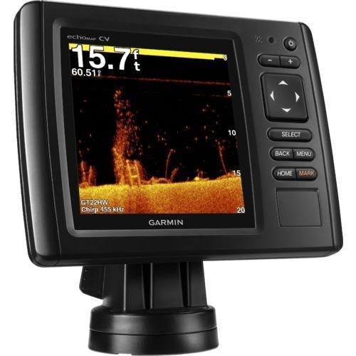
Sonar Garmin Echo Map 53 CV
Disponível desde 04 de Agosto de 2018
Última listagem em 25 de Abril de 2024

código: #6647
Por:
US$ 565,00
* Os preços e a disponibilidade estão
sujeitos a alterações sem aviso prévio.
Informar preço incorreto ou indisponibilidade
DETALHES DO PRODUTO
| INFORMAÇÕES BÁSICAS | |
|---|---|
| Marca | Garmin |
INFORMAÇÕES DO PRODUTO
5-inch Combo with Great Features for the Money
High-contrast color display with keypad control with preloaded Garmin LakeVü™ HD maps
Built-in ClearVü scanning sonar with the clearest images on the water
Built-in 500 W (RMS) HD-ID™ sonar (4,000 W peak-to-peak)
5 Hz Internal GPS updates position and heading 5 times per second
Tilt/swivel quick-disconnect mount
echoMAP 53cv includes a 5-inch high-contrast color display with automatic backlight adjustment. Fast, responsive 5 Hz GPS/GLONASS refreshes your position and heading 5 times each second to make your movement on the screen more fluid. echoMAP comes with 1 transducer for 77/200 kHz HD-ID sonar and Garmin ClearVü™, the clearest scanning sonar on the water. It also supports Minn Kota® and MotorGuide® trolling motors with integrated transducers. The combo's cords plug directly into the mount, allowing you to quickly install and remove your device from power and the mount. Transom and trolling motor mount included.
Clearest Scanning Sonar on the Water
Garmin ClearVü scanning sonar gives you a nearly photographic image down to 750-feet below your boat. You clearly see structure, submerged objects and fish! Traditional Garmin HD-ID sonar and ClearVü scanning sonar are combined into one transducer. Also provides HD-ID support for Minn Kota and MotorGuide trolling motors with integrated transducers. The echoMAP 53cv also includes sonar-recording capability that coordinates the timing of the sonar return with your boat's position and saves digital information for playback on a computer using free HomePort™ planning software. Use the User Data Sharing Cable to share waypoints and routes between multiple devices.
Preloaded LakeVü HD Maps
These highly detailed freshwater maps include 17,000+ U.S. lakes, rivers and reservoirs (more than double the number of preloaded lakes of any competitor). That number also includes more than 6,700 HD lakes with 1-foot contours shoreline to shoreline (again, two times more than our competition). LakeVü HD gives you excellent detail of underwater features plus Safety Shading that allows you to designate a minimum depth; interstates, highways, general roads and bridges; designated fishing areas; and points of interest, such as docks, boat ramps, marinas and campgrounds.
Heading and Position Refreshed 5 Times per Second
Fast, responsive 5 Hz GPS/GLONASS refreshes your position and heading 5 times each second to make your movement on the screen more fluid. It makes dropping up to 5,000 accurate waypoints and finding your way back to your secret fishing hot spots quick and easy.
Take Your echoMAP with You
When you’re off the water, it’s easy to keep your echoMAP safe and secure. You don’t have to mess with plugging and unplugging wires from the unit because the cords plug directly into the mount. This allows you to quickly install and remove your echoMAP from power and the mount.
Upgrade with the Best Garmin Maps on the Water
A single microSD™ card slot provides expandable memory for accessory map purchases such as LakeVü HD Ultra or BlueChart® g2 HD or BlueChart g2 Vision HD. LakeVü HD Ultra adds high-resolution relief shading, Dynamic Lake Level, Depth Range Shading and more than 70 MaxDef lakes. LakeVü HD Ultra and BlueChart g2 Vision HD also provide exclusive Garmin Auto Guidance that directs you right to your hot spots by instantly creating an on-screen path based on your boat’s specifications that you can follow to avoid shallow water and other charted obstructions.
Enhanced Auto Guidance
Just enter the location where you want to go and patented Garmin Auto Guidance technology instantly searches through relevant charts to create a safe virtual pathway on the display that helps you avoid low bridges, shallow water and other charted obstructions en route.
Better still, with enhanced Version 2.0, you now have access to even more features and capabilities. You’re able to adjust the calculated Auto Guidance pathway by inserting “via” points at interim stops or landmarks along your desired route. You can easily review hazard points along your calculated path. And you can even engage your compatible Garmin autopilot to follow the Auto Guidance route, automatically. Other 2.0 enhancements give you the ability to calculate arrival times at any point on your route (great for timing arrivals to correspond with bridge openings and other time-critical events). Better still, you can now save your plotted Auto Guidance paths for future navigation by backing them up on an SD™ card with your BlueChart g2 Vision HD or Garmin LakeVü HD Ultra cartography¹.
GPX Waypoints Transfer
If you have waypoints, tracks or frequently used routes stored on another manufacturer’s GPS product – or on a Garmin handheld device – now it’s easier than ever to transfer those items to your new Garmin chartplotter, via industry-standard GPX software formatting. GPX is an open standard format for GPS data exchange across platforms and applications. With this easy-to-use interface technology, Garmin has taken “no waypoint left behind” to a whole new level of trade-up convenience.
Create your own HD maps
Quickdraw Contours is a free, easy-to-use software feature that is already installed on your compatible Garmin device. It instantly creates your very own personalized HD fishing maps with 1-foot contours. Tailor them to fit your needs. They are your maps. You own them. Keep the data to yourself or share it with Garmin or your friends. There’s no special surveying expertise required. You just fish while it creates maps. You don’t have to wait around or send your files away like other mapping software requires — your results appear instantly. Use with any Garmin Panoptix™, any HD-ID™, any CHIRP-enabled, Garmin ClearVü transducer or NMEA 2000®-compatible depth transducer. Have more than 1 sonar device installed onboard? Quickdraw Contours automatically selects the most capable sonar device to provide the very best results for you!
Multiple Depth Range Shading
Designate up to 10 different depth ranges each with its own color. Makes it easier to view target depths at a glance.